In today’s fast-paced industries, precision is key—especially in sectors like agriculture and construction. RTK GPS (Real-Time Kinematic Global Positioning System) has emerged as a game-changer, offering centimeter-level accuracy that revolutionizes the way professionals approach tasks. In this article, we explore the top 5 applications of rtk gps in agriculture and construction, and how this technology is setting new standards in efficiency and productivity.
What is RTK GPS?
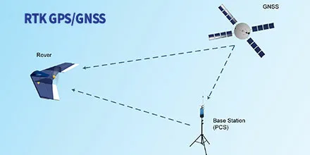
RTK GPS is an advanced positioning technique that uses a fixed base station and a mobile receiver to correct satellite data in real-time. This results in extremely accurate location tracking—often within 1 to 2 centimeters. This high precision makes it ideal for industries where even minor errors can lead to significant costs or risks.
1. Precision Farming
One of the most impactful applications of RTK GPS in agriculture is precision farming. Farmers can now plant, fertilize, and harvest with remarkable accuracy. RTK systems help in:
- Guiding tractors along exact paths with minimal overlap
- Applying seeds and fertilizers only where needed
- Reducing input costs while maximizing yield
This ensures better crop health and contributes to sustainable farming practices.
2. Land Surveying and Plot Mapping
In both agriculture and construction, accurate land measurement is crucial. RTK GPS enables:
- Fast and accurate boundary marking
- Slope and elevation analysis
- Digital mapping for project planning
With this technology, land surveys that once took days can now be completed in hours, and with much greater accuracy.
3. Automated Machine Control
One of the leading applications of RTK GPS in construction is its integration with heavy machinery. Bulldozers, graders, and excavators equipped with RTK systems can:
- Automatically follow design specifications
- Reduce the need for manual staking
- Minimize human error in earth-moving tasks
This not only speeds up construction timelines but also reduces material waste and rework.
4. Drainage and Irrigation Planning
In agriculture, water management is a major concern. RTK GPS assists in designing efficient drainage and irrigation systems by:
- Analyzing land elevation data
- Planning gravity-fed water flows
- Ensuring even distribution of water across fields
This application helps reduce water waste and prevents soil erosion.
5. Infrastructure and Road Construction
RTK GPS is essential in large-scale infrastructure projects. It supports:
- Precise alignment of roads, bridges, and tunnels
- Real-time progress tracking
- Accurate placement of structural elements
As one of the top 5 applications of RTK GPS in agriculture and construction, its role in infrastructure ensures long-term safety and compliance with engineering standards.
Final Thoughts
The top 5 applications of RTK GPS in agriculture and construction demonstrate the transformative power of this technology. From improving farming efficiency to enhancing construction accuracy, RTK GPS is not just a tool—it’s a critical component for modern-day operations. As the technology becomes more accessible, even more industries are expected to adopt RTK systems to boost productivity and reduce errors.


